Take charge of your next adventure with BaseCamp, software to view and organize your maps, waypoints, routes, and tracks and send them to your Garmin device.
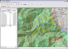
BaseCamp displays your topographic map data in 2-D or 3-D on your computer screen, including elevation profiles. Then you can view and rotate the maps from any angle.
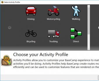
You can plan your route. Prepare for you trip by creating waypoints and routes on your computer and then loading them to your device.
Estimate the difficulty of your hike before you start with BaseCamp’s Track Draw feature to trace your intended path. Instantly view the elevation changes over your entire route. When your trip is done, BaseCamp shows an animated playback of your routes and tracks over time, so you can see where you’ve been.


Comments (5)