Take charge of your next adventure with BaseCamp, software to view and organize your maps, waypoints, routes, and tracks and send them to your Garmin device.
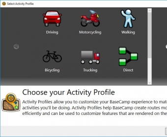
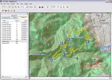
BaseCamp displays your topographic map data in 2-D or 3-D on your computer screen, including contour lines and elevation profiles. Load map data from your handheld device, or import maps you’ve downloaded or purchased on DVD or microSD™ card. Consider our TOPO series maps, which offer detail on a scale of either 1:100,000 or 1:24,000.
Features:
* Import and view a range of maps, including our TOPO and City Navigator series.
* View BirdsEye Satellite Imagery or BirdsEye Select raster maps, and transfer the data to your device (subscriptions required).
* Create, edit, and organize waypoints, routes, tracks and more on your computer.
* Transfer maps, waypoints, routes, tracks and geotagged photos between your computer and device. Use your computer to back up and archive your adventures.
* Install new maps onto your device with the integrated MapInstall tool.
* Create and share geotagged photos.
* View playback of routes and tracks over time.
* Print full-page or multi-page tiled maps.
* Search for geocaches through integrated OpenCaching support.
* Keep your device up-to-date with WebUpdater.


Comments (5)